
Guidebook for Buffalo National River Area
Food scene
Don't want to cook breakfast, this place has you covered!
Best biscuits & gravy I have ever had!
They also have lunch & dinner menus!
KINGSTON STATION
5283 AR-21Don't want to cook breakfast, this place has you covered!
Best biscuits & gravy I have ever had!
They also have lunch & dinner menus!
Great place for great food! Approx. 40 minutes from the cabin in Jasper, AR.
Jasper is a quaint town that offers food, live music, and shops.
69 Recomendado por los habitantes de la zona
Ozark Cafe
107 E Court StGreat place for great food! Approx. 40 minutes from the cabin in Jasper, AR.
Jasper is a quaint town that offers food, live music, and shops.
You'll be talking about this food months after you visit! The Low Gap Cafe is a must visit for food! It's not fancy, but it is tasty!
63 Recomendado por los habitantes de la zona
Low Gap Cafe
603 East StreetYou'll be talking about this food months after you visit! The Low Gap Cafe is a must visit for food! It's not fancy, but it is tasty!
If you want a great sandwich on the run....this is the place to go! They also have delicious breakfast burritos in the morning.
28 Recomendado por los habitantes de la zona
Buffalo Outdoor Center
4699 AR-43If you want a great sandwich on the run....this is the place to go! They also have delicious breakfast burritos in the morning.
Buffalo National River Area
Scenic and quaint are two words that well describe the town of Jasper, AR. Located in Newton County, the small town is surrounded by natural beauty of where the nation's first national river, the Buffalo, begins to flow.
This quaint Ozark Mountain town was named by American Cowboy magazine as one of their "Five Spots for Family Reunions" (September 2012). Jasper, AR has a picturesque downtown square with a beautiful courthouse in the middle and gazebos on the grounds. Every year, people gather in Jasper for the annual Buffalo River Elk Festival, celebrating the reintroduction of elk to the area.
28 Recomendado por los habitantes de la zona
Jasper
Scenic and quaint are two words that well describe the town of Jasper, AR. Located in Newton County, the small town is surrounded by natural beauty of where the nation's first national river, the Buffalo, begins to flow.
This quaint Ozark Mountain town was named by American Cowboy magazine as one of their "Five Spots for Family Reunions" (September 2012). Jasper, AR has a picturesque downtown square with a beautiful courthouse in the middle and gazebos on the grounds. Every year, people gather in Jasper for the annual Buffalo River Elk Festival, celebrating the reintroduction of elk to the area.
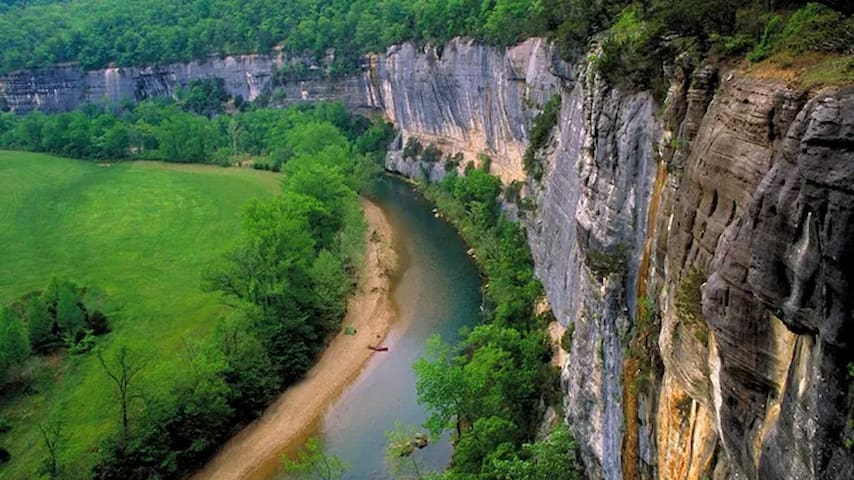
The unincorporated community of Boxley is more of a place than a town. But it’s one heck of a place.
Boxley is located along the Ozark Highlands Scenic Byway, which is a 35-mile section of Ark. 21. Boxley is best known for its location along the Buffalo, the nation’s first national river.
The area is ripe with canoe and kayak outfitters, campsites, hiking trails and cabin rentals. Views in the vicinity include towering limestone bluffs, river rapids, the Boxley Valley Historic District, the Parker Hickman Homestead and the Villines Cabin - all located within the national park.
Boxley Valley is adjacent to Smith Creek Preserve and popular day hikes such as Whitaker Point, Lost Valley, Glory Hole and Steel Creek. The majority of Boxley’s residents are elk roaming the Buffalo National River corridor. Pull-offs along the highway are popular with photographers and tourists stopping to view the elk in the pastures.
Boxley
The unincorporated community of Boxley is more of a place than a town. But it’s one heck of a place.
Boxley is located along the Ozark Highlands Scenic Byway, which is a 35-mile section of Ark. 21. Boxley is best known for its location along the Buffalo, the nation’s first national river.
The area is ripe with canoe and kayak outfitters, campsites, hiking trails and cabin rentals. Views in the vicinity include towering limestone bluffs, river rapids, the Boxley Valley Historic District, the Parker Hickman Homestead and the Villines Cabin - all located within the national park.
Boxley Valley is adjacent to Smith Creek Preserve and popular day hikes such as Whitaker Point, Lost Valley, Glory Hole and Steel Creek. The majority of Boxley’s residents are elk roaming the Buffalo National River corridor. Pull-offs along the highway are popular with photographers and tourists stopping to view the elk in the pastures.
If you’ve ever longed for an escape to the true beautiful middle of nowhere, Ponca is that place. Tucked into the mountainous upper Buffalo National River wilderness, this tiny town is surrounded by some of the most grand hiking and floating scenery in mid-America. From the pristine river that flows through it to the craggy, towering cliffs that rise above it, Ponca is your basecamp for splendid national park adventure right here in Arkansas. March through June, river paddlers enjoy jaw-dropping scenery and easy side hikes to places like Hemmed-In Hollow, which at nearly 210 feet tall, is the tallest waterfall between the Appalachians and Rockies.
27 Recomendado por los habitantes de la zona
Ponca
If you’ve ever longed for an escape to the true beautiful middle of nowhere, Ponca is that place. Tucked into the mountainous upper Buffalo National River wilderness, this tiny town is surrounded by some of the most grand hiking and floating scenery in mid-America. From the pristine river that flows through it to the craggy, towering cliffs that rise above it, Ponca is your basecamp for splendid national park adventure right here in Arkansas. March through June, river paddlers enjoy jaw-dropping scenery and easy side hikes to places like Hemmed-In Hollow, which at nearly 210 feet tall, is the tallest waterfall between the Appalachians and Rockies.
Hiking
This spot is a must see!
Whitaker Point Trail (Hawksbill Crag) is a 2.9 mile heavily trafficked out and back trail located in the Ozark National Forrest and features a waterfall and an incredible viewpoint. The trail is primarily used for hiking and is accessible year-round. It's rated as moderate, but I found it to be a fairly easy hike.
59 Recomendado por los habitantes de la zona
Hawk's Bill Crag/Whitaker Point
County Road 406This spot is a must see!
Whitaker Point Trail (Hawksbill Crag) is a 2.9 mile heavily trafficked out and back trail located in the Ozark National Forrest and features a waterfall and an incredible viewpoint. The trail is primarily used for hiking and is accessible year-round. It's rated as moderate, but I found it to be a fairly easy hike.
Lost Valley Trail is located near the Boxley Valley Historic District on Hwy. 43 and is the most popular hike at Buffalo National River. Lost Valley Trail is an easy to moderate hike with occasional benches on the first portion of trail for resting and watching wildlife. Lost Valley Trail leaves the parking area and gently winds up the box canyon, passing beneath groves of American beech trees. The trail leads you to an emerald-blue pool of water with an 8-ft waterfall flowing out of a small opening in the bluff, known as the Natural Bridge. The trail continues up stone steps, winding along the Clark Creek drainage giving way to a massive 200-ft bluff shelter, known as Cob Cave. The gem of the hike is Eden Falls. The picturesque Eden Falls cascades 53 feet over towering cliffs offering visitors a firsthand view of what the Ozark Mountains have to offer. Visitors can either loop back around to the main trail or continue on a spur trail to the peak of Eden Falls. The trail leading to Eden Falls is rugged and steep; visitors should use extreme caution when taking this route. The trail winds up the bluff line to a 200-ft cave, and then gives way to a 25-ft waterfall inside. A flashlight and some agility will be needed to view the waterfall in the cave. The trail ends here at the mouth of the cave.
56 Recomendado por los habitantes de la zona
Lost Valley Trailhead
Lost Valley RoadLost Valley Trail is located near the Boxley Valley Historic District on Hwy. 43 and is the most popular hike at Buffalo National River. Lost Valley Trail is an easy to moderate hike with occasional benches on the first portion of trail for resting and watching wildlife. Lost Valley Trail leaves the parking area and gently winds up the box canyon, passing beneath groves of American beech trees. The trail leads you to an emerald-blue pool of water with an 8-ft waterfall flowing out of a small opening in the bluff, known as the Natural Bridge. The trail continues up stone steps, winding along the Clark Creek drainage giving way to a massive 200-ft bluff shelter, known as Cob Cave. The gem of the hike is Eden Falls. The picturesque Eden Falls cascades 53 feet over towering cliffs offering visitors a firsthand view of what the Ozark Mountains have to offer. Visitors can either loop back around to the main trail or continue on a spur trail to the peak of Eden Falls. The trail leading to Eden Falls is rugged and steep; visitors should use extreme caution when taking this route. The trail winds up the bluff line to a 200-ft cave, and then gives way to a 25-ft waterfall inside. A flashlight and some agility will be needed to view the waterfall in the cave. The trail ends here at the mouth of the cave.
This trail leads to one of the prettiest waterfall areas in Buffalo River country. The fall is easily 50 feet tall with the surrounding bluff line offering the chance to sit for a spell and gaze off into the wilderness below.
The trailhead is located exactly 3 miles from Compton (9 miles from Ponca on Hwy 43 N) down a gravel road that takes off just about opposite of the Compton Post Office. (You’ll see a wooden “Wilderness Access” sign as you approach this road from the direction of Ponca.) This is the same road you take to access the Hemmed-In Hollow trailhead.
10 Recomendado por los habitantes de la zona
Hideout Hollow Trailhead
Erbie RoadThis trail leads to one of the prettiest waterfall areas in Buffalo River country. The fall is easily 50 feet tall with the surrounding bluff line offering the chance to sit for a spell and gaze off into the wilderness below.
The trailhead is located exactly 3 miles from Compton (9 miles from Ponca on Hwy 43 N) down a gravel road that takes off just about opposite of the Compton Post Office. (You’ll see a wooden “Wilderness Access” sign as you approach this road from the direction of Ponca.) This is the same road you take to access the Hemmed-In Hollow trailhead.
This has to be the one of the most unique waterfalls in all the Ozarks. Dismal Creek has literally drilled a hole right through an overhanging bluff. Most times of the year, it is nothing more than a trickle, but after some good rain, this is something spectacular. It is also quite a sight in the winter when the waterfall becomes frozen!
This waterfall is located in the Ozark National Forest, between Fallsville and Edwards Junction, south of Boxley Valley. To get to the parking spot, travel East out of Fallsville on AR Hwy 16/21 for 5.7 miles. You will pass a large red barn that has a big, white "E" painted on the side of it. Go ½ mile past this barn, and you will see a pull off on the Right side of the road, opposite from a house up on a hill. (If you have come to the Cassville Baptist Church, you've gone 0.7 miles too far.) You can also get here from Edwards Junction, by traveling West on AR Hwy 16/21 for 2.3 miles, which would make it 0.7 miles past the Cassville Baptist Church. Then, you will Turn Left across from the house up on the hill.
Park along this Jeep road near the highway, there is room for only two or three vehicles at the most. (If you have a 4wd, you can drive another ¼ mile down this road and park.) From the highway, hike along this Jeep road, and Turn Right at the bulletin board. There will be a smaller old roadbed that heads down the hill. It gets a little steep as it curves back to the right, then crosses the main stream at the bottom. This is Dismal Creek, and is what feeds the waterfall. The old road swings back left and heads downhill some more, eventually turning narrower into more or less of a trail, before coming to the top of the bluffline. Here, you will see where the creek has drilled through the rock. Over on the right, there is a way to make it to the bottom, but it is a little steep and can be very slick in places. Use caution.
8 Recomendado por los habitantes de la zona
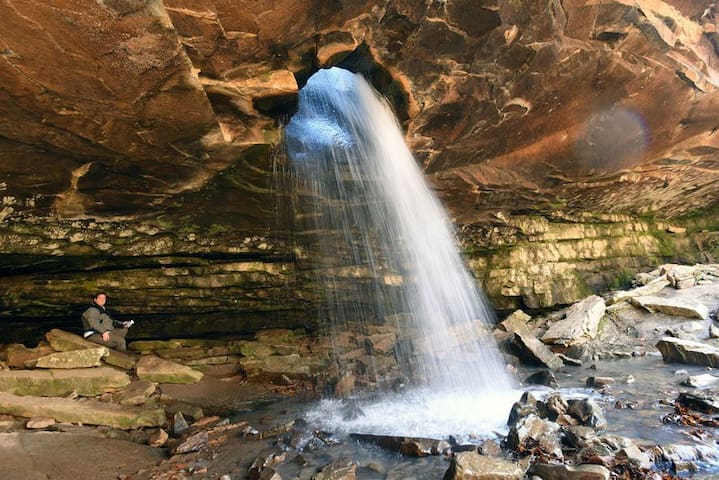
Glory Hole Falls Trail
Glory Hole Falls TrailThis has to be the one of the most unique waterfalls in all the Ozarks. Dismal Creek has literally drilled a hole right through an overhanging bluff. Most times of the year, it is nothing more than a trickle, but after some good rain, this is something spectacular. It is also quite a sight in the winter when the waterfall becomes frozen!
This waterfall is located in the Ozark National Forest, between Fallsville and Edwards Junction, south of Boxley Valley. To get to the parking spot, travel East out of Fallsville on AR Hwy 16/21 for 5.7 miles. You will pass a large red barn that has a big, white "E" painted on the side of it. Go ½ mile past this barn, and you will see a pull off on the Right side of the road, opposite from a house up on a hill. (If you have come to the Cassville Baptist Church, you've gone 0.7 miles too far.) You can also get here from Edwards Junction, by traveling West on AR Hwy 16/21 for 2.3 miles, which would make it 0.7 miles past the Cassville Baptist Church. Then, you will Turn Left across from the house up on the hill.
Park along this Jeep road near the highway, there is room for only two or three vehicles at the most. (If you have a 4wd, you can drive another ¼ mile down this road and park.) From the highway, hike along this Jeep road, and Turn Right at the bulletin board. There will be a smaller old roadbed that heads down the hill. It gets a little steep as it curves back to the right, then crosses the main stream at the bottom. This is Dismal Creek, and is what feeds the waterfall. The old road swings back left and heads downhill some more, eventually turning narrower into more or less of a trail, before coming to the top of the bluffline. Here, you will see where the creek has drilled through the rock. Over on the right, there is a way to make it to the bottom, but it is a little steep and can be very slick in places. Use caution.
Beautiful Hike...especially after a rain.
11 Recomendado por los habitantes de la zona
Sweden Creek Falls
697 Madison 3795Beautiful Hike...especially after a rain.
Kayaks, Canoes, Zip Lining, & Adventure Park
Visit the historic Lost Valley General Store for fun stickers, T-shirts, and ice cream!
18 Recomendado por los habitantes de la zona
Lost Valley Canoe & Lodging
Arkansas 43Visit the historic Lost Valley General Store for fun stickers, T-shirts, and ice cream!
Buffalo Outdoor Center
4699 AR-43Rent a UTV and explore this incredible adventure park.
10 Recomendado por los habitantes de la zona
Wilderness Rider Buffalo Ranch & Adventure Park
Rent a UTV and explore this incredible adventure park.
T-Shirts and Souvenirs
Bubba's has something for everyone! We love their t-shirts and hoodies. They also offer amazing coffee mugs from Deneen Pottery.
8 Recomendado por los habitantes de la zona
Bubba's Buffalo River Store
206 Court StBubba's has something for everyone! We love their t-shirts and hoodies. They also offer amazing coffee mugs from Deneen Pottery.
Sightseeing
Roark Bluff, Arkansas 72624, EE. UU.
Consejos para la ciudad
Antes de que te vayas
Food - Grocery Store
There is a Wal-Mart located in Huntsville, AR approx 22 minutes from the cabin.