
JC Cabrera guidebook- Mountains & Lakes
My favorite place to do jet ski
This place is one hour from "La Casita de Tecla"
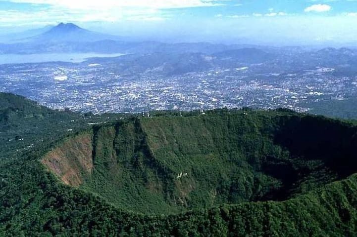
Lake Coatepeque is a formation of volcanic origin, located in the municipality of El Congo in the department of Santa Ana, El Salvador. It is located in the western part of the country.
Lake Coatepeque is one of the most beautiful tourist places to visit in El Salvador. This lake has a large area where you can practice various water sports, in addition to its beauty it has an excellent panoramic view of the Santa Ana volcano and the green hill.
It also has a great variety of hotels and restaurants. In this lake is the famous ferry in which for a cost you can cross the lake.
One of the tourist attractions of Lake Coatepeque is its change in the color of its waters, although it is caused by a type of micro-marine algae, the turquoise color they cause is very striking.
79 Recomendado por los habitantes de la zona
Lago de Coatepeque
This place is one hour from "La Casita de Tecla"
Lake Coatepeque is a formation of volcanic origin, located in the municipality of El Congo in the department of Santa Ana, El Salvador. It is located in the western part of the country.
Lake Coatepeque is one of the most beautiful tourist places to visit in El Salvador. This lake has a large area where you can practice various water sports, in addition to its beauty it has an excellent panoramic view of the Santa Ana volcano and the green hill.
It also has a great variety of hotels and restaurants. In this lake is the famous ferry in which for a cost you can cross the lake.
One of the tourist attractions of Lake Coatepeque is its change in the color of its waters, although it is caused by a type of micro-marine algae, the turquoise color they cause is very striking.
Sightseeing
This place is 15 minutes from "La Casita de Tecla"
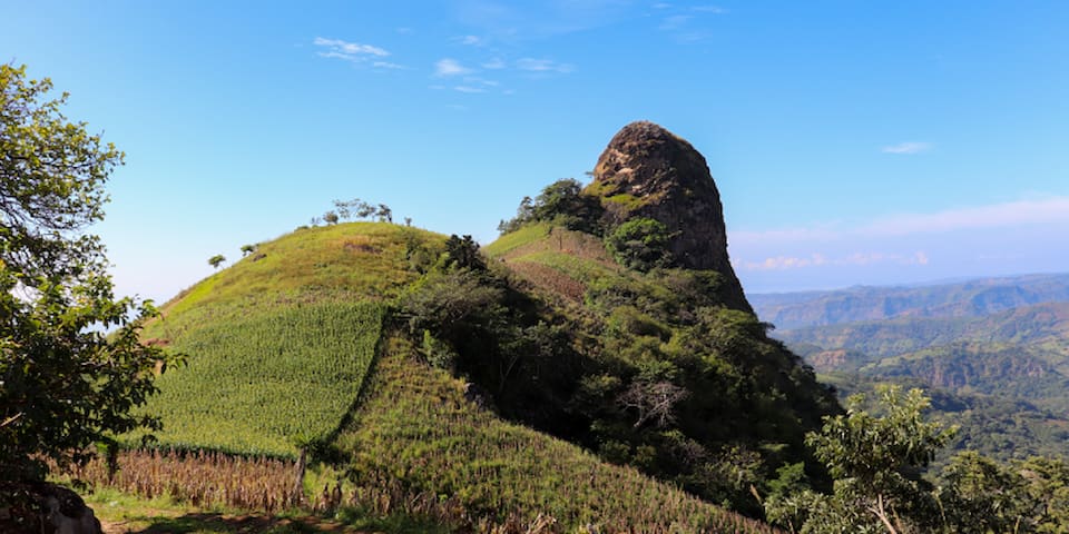
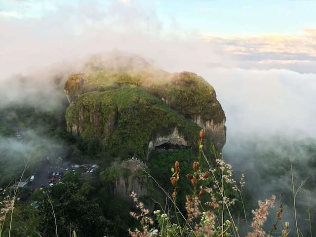
Among the natural beauties that attract more and more tourists, is El Peñón de Comasagua, which is located in the municipality of Comasagua, department of La Libertad, El Salvador.
The Peñón de Comasagua is described as an enormous stone of great magnitude that stands out between mountains and pastures. Due to its proximity to the Salvadoran coast, it is said that formerly when the port of La Libertad received boats, this huge rock served as a signal to sailors of its proximity to the port, since it is possible to visualize it from the high seas. The navigators gave it the name of El Faro. Also another name that is given is the Salvadoran Kepis that it is believed gave to the imagination to place it on the national shield of El Salvador.
The Peñón de Comasagua is located approximately 5 kilometers from the urban area of the municipality of Comasagua and is at an altitude of 900 meters above sea level. The height of this rock is approximately 300 meters.
El Peñón de Comasagua
Carretera a la ShilaThis place is 15 minutes from "La Casita de Tecla"
Among the natural beauties that attract more and more tourists, is El Peñón de Comasagua, which is located in the municipality of Comasagua, department of La Libertad, El Salvador.
The Peñón de Comasagua is described as an enormous stone of great magnitude that stands out between mountains and pastures. Due to its proximity to the Salvadoran coast, it is said that formerly when the port of La Libertad received boats, this huge rock served as a signal to sailors of its proximity to the port, since it is possible to visualize it from the high seas. The navigators gave it the name of El Faro. Also another name that is given is the Salvadoran Kepis that it is believed gave to the imagination to place it on the national shield of El Salvador.
The Peñón de Comasagua is located approximately 5 kilometers from the urban area of the municipality of Comasagua and is at an altitude of 900 meters above sea level. The height of this rock is approximately 300 meters.
This place is located 25 minutes from "La casita de Tecla"
El Boquerón National Park is located between the municipalities of Santa Tecla and San Salvador, and the departments of La Libertad and San Salvador, El Salvador.
El Boquerón, as it is mostly known among the locals, contains a protected area that includes the crater of the San Salvador volcano and a forest full of trees and plants typical of the area.
Tourism in the El Boquerón national park
Regarding tourism in El Boquerón, within the park there is a forest with trails and a small museum with the history of the place, it is very important to wear a coat because due to its altitude of 1,839.39 meters above sea level, the climate is cold, and there are constant rains. The trails are uphill and downhill, so you should wear comfortable shoes. There are walks to the bottom of the crater but these walks are private, the coordinators or guides should be canceled, it should be noted that due to security protocol it is advisable to avoid going down to the bottom of the crater, due to the constant and unforeseen seismic that exists in the country .
Calle al Parque Nacional el Boqueron
Calle al Parque Nacional el BoqueronThis place is located 25 minutes from "La casita de Tecla"
El Boquerón National Park is located between the municipalities of Santa Tecla and San Salvador, and the departments of La Libertad and San Salvador, El Salvador.
El Boquerón, as it is mostly known among the locals, contains a protected area that includes the crater of the San Salvador volcano and a forest full of trees and plants typical of the area.
Tourism in the El Boquerón national park
Regarding tourism in El Boquerón, within the park there is a forest with trails and a small museum with the history of the place, it is very important to wear a coat because due to its altitude of 1,839.39 meters above sea level, the climate is cold, and there are constant rains. The trails are uphill and downhill, so you should wear comfortable shoes. There are walks to the bottom of the crater but these walks are private, the coordinators or guides should be canceled, it should be noted that due to security protocol it is advisable to avoid going down to the bottom of the crater, due to the constant and unforeseen seismic that exists in the country .
This place is located one hour from "La Casita de Tecla"
La Puerta Del Diablo is a tourist site, located in the municipality of Panchimalco, department of San Salvador, just 13 kilometers from the capital (San Salvador).
Tourism at the Devil's Gate
Tourism in the Puerta del Diablo is mountain, climbing the rocky mountains and appreciating different viewpoints that the place has, so you must wear appropriate clothes and shoes, with the gastronomy you can find variety typical of the area.
8 Recomendado por los habitantes de la zona
Devil's Door
This place is located one hour from "La Casita de Tecla"
La Puerta Del Diablo is a tourist site, located in the municipality of Panchimalco, department of San Salvador, just 13 kilometers from the capital (San Salvador).
Tourism at the Devil's Gate
Tourism in the Puerta del Diablo is mountain, climbing the rocky mountains and appreciating different viewpoints that the place has, so you must wear appropriate clothes and shoes, with the gastronomy you can find variety typical of the area.
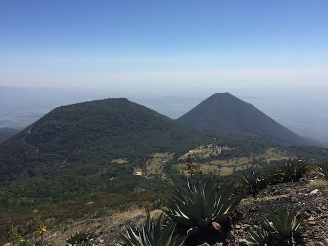
This place is located an hour and a half from "La Casita de Tecla"
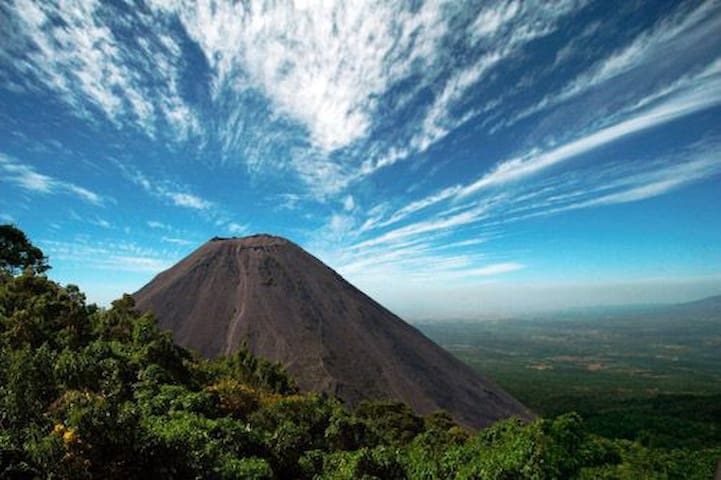
Visit the youngest volcano in El Salvador and in the world, which remains active and represents a challenge for tourists.
Its name in Nahuat means: place of the black sands, which characterize it to date. It is also known as the Pacific Lighthouse, because the ships were guided by the constant eruptions and lava flows of this natural leviathan.
This 1,950-meter-high volcano above sea level with an inclination angle around 45º continues active, with its commanding presence in the middle of the thick vegetation of the area.
Its ascent is medium level (6/10), and visitors will experience a climate that varies from the highest to the lowest temperatures, therefore, it is recommended to wear comfortable clothing, bring with you 1.5 liters of water, sunglasses, sunscreen, cap and footwear suitable for rough terrain.
13 Recomendado por los habitantes de la zona
Izalco
This place is located an hour and a half from "La Casita de Tecla"
Visit the youngest volcano in El Salvador and in the world, which remains active and represents a challenge for tourists.
Its name in Nahuat means: place of the black sands, which characterize it to date. It is also known as the Pacific Lighthouse, because the ships were guided by the constant eruptions and lava flows of this natural leviathan.
This 1,950-meter-high volcano above sea level with an inclination angle around 45º continues active, with its commanding presence in the middle of the thick vegetation of the area.
Its ascent is medium level (6/10), and visitors will experience a climate that varies from the highest to the lowest temperatures, therefore, it is recommended to wear comfortable clothing, bring with you 1.5 liters of water, sunglasses, sunscreen, cap and footwear suitable for rough terrain.
This place is located an hour and a half from "La Casita de Tecla"
Put your endurance to the test by climbing to the top of the Ilamatepec volcano, also called the Santa Ana volcano. If you make it, you are sure to have some of the most impressive views of the area, with the turquoise waters of Lake Coatepeque as a background.
Located in the department of Santa Ana, this colossus has an altitude of 2,381 meters above sea level, the highest in El Salvador. Its last eruptions occurred in 2005.
This volcano is part of the Los Volcanes Complex in the Apaneca mountain range, within a tropical mountainous cloud forest, in a coffee-growing region about 65 kilometers west of the capital city. The main activities in the region are agriculture and tourism, so you will be rewarded by the luscious landscapes that you will see from the moment you start your ride along the road, lined with fruit stalls that characterize the area.
Volcan De Santa Ana O Ilamatepec
This place is located an hour and a half from "La Casita de Tecla"
Put your endurance to the test by climbing to the top of the Ilamatepec volcano, also called the Santa Ana volcano. If you make it, you are sure to have some of the most impressive views of the area, with the turquoise waters of Lake Coatepeque as a background.
Located in the department of Santa Ana, this colossus has an altitude of 2,381 meters above sea level, the highest in El Salvador. Its last eruptions occurred in 2005.
This volcano is part of the Los Volcanes Complex in the Apaneca mountain range, within a tropical mountainous cloud forest, in a coffee-growing region about 65 kilometers west of the capital city. The main activities in the region are agriculture and tourism, so you will be rewarded by the luscious landscapes that you will see from the moment you start your ride along the road, lined with fruit stalls that characterize the area.
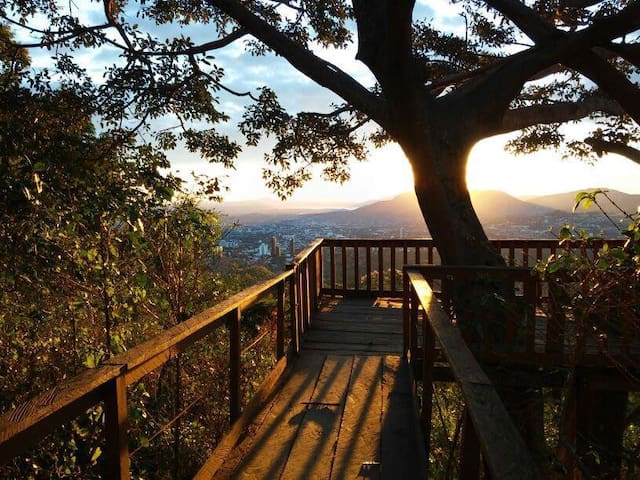
My place to hike and breathe fresh air
This place is located 10 minutes from "La Casita de Tecla"
The El Espino Ecopark is a forest for the most part coffee growing, which is located on the slopes of the San Salvador volcano and is located in the city of Santa Tecla, head of the department of La Libertad, El Salvador.
The territorial extension of the El Espino Ecopark is 55 protected blocks out of a total of 550 that comprise the El Espino Estate, from which the park's name comes.
Tourism in the El Espino Ecopark
Inside the park there are coffee trails and streets where you can walk in the tranquility of nature and enjoy a day with the family. It also has picnic areas where you can bring ready-made food.
Being on the slopes of the San Salvador volcano, El Espino Ecopark has several viewpoints where you can see the city of Santa Tecla and part of the city of San Salvador.
7 Recomendado por los habitantes de la zona
Ecoparque El Espino
20 Blvr. Sta. ElenaThis place is located 10 minutes from "La Casita de Tecla"
The El Espino Ecopark is a forest for the most part coffee growing, which is located on the slopes of the San Salvador volcano and is located in the city of Santa Tecla, head of the department of La Libertad, El Salvador.
The territorial extension of the El Espino Ecopark is 55 protected blocks out of a total of 550 that comprise the El Espino Estate, from which the park's name comes.
Tourism in the El Espino Ecopark
Inside the park there are coffee trails and streets where you can walk in the tranquility of nature and enjoy a day with the family. It also has picnic areas where you can bring ready-made food.
Being on the slopes of the San Salvador volcano, El Espino Ecopark has several viewpoints where you can see the city of Santa Tecla and part of the city of San Salvador.