
Ταξιδιωτικός οδηγός του/της Μaria
Γειτονιές
Zacharo is a town and municipality in southwestern Greece. It belongs to the Elis regional unit, in the region of West Greece.
Zacharo is situated on the coast of the Gulf of Kyparissia and is part of the Ionian Sea.
The town of Zacharo is 18 km south of Olympia, 28 km southeast of Pyrgos, 65 km northwest of Kalamata and 65 km west of Tripoli. The town is crossed by the Greek National Road 9/E55, that links Patras with Kalamata.It has a well organized market . The beach of Zacharo is one of the longest in Greece.
Zacharo
Zacharo is a town and municipality in southwestern Greece. It belongs to the Elis regional unit, in the region of West Greece.
Zacharo is situated on the coast of the Gulf of Kyparissia and is part of the Ionian Sea.
The town of Zacharo is 18 km south of Olympia, 28 km southeast of Pyrgos, 65 km northwest of Kalamata and 65 km west of Tripoli. The town is crossed by the Greek National Road 9/E55, that links Patras with Kalamata.It has a well organized market . The beach of Zacharo is one of the longest in Greece.
The town is situated on the Gulf of Kyparissia, a bay of the Ionian Sea. It is 38 km north of Pylos, 46 km northwest of Kalamata and 51 km southeast of Pyrgos. The Greek National Road 9 (Pyrgos - Methoni) passes through the town. The town has a port, which is mainly used for cargo purposes. On a hill east of the town centre lies the upper town of Kiparissia and there is a fortress built during the Frankish period.
22 Recomendado por los habitantes de la zona
Kyparissia
The town is situated on the Gulf of Kyparissia, a bay of the Ionian Sea. It is 38 km north of Pylos, 46 km northwest of Kalamata and 51 km southeast of Pyrgos. The Greek National Road 9 (Pyrgos - Methoni) passes through the town. The town has a port, which is mainly used for cargo purposes. On a hill east of the town centre lies the upper town of Kiparissia and there is a fortress built during the Frankish period.
Kakovatos is a small fishing village in Elis near the town of Zacharo.There are many fish tavernes and an organized beach with soft sand,clean water. .and lot of space.
9 Recomendado por los habitantes de la zona
Kakovatos
Kakovatos is a small fishing village in Elis near the town of Zacharo.There are many fish tavernes and an organized beach with soft sand,clean water. .and lot of space.
Αξιοθέατα
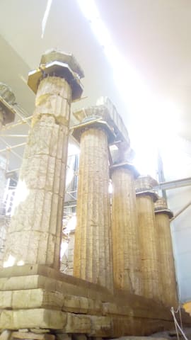
Messene is one of the most important cities of antiquity, and one which still has a great deal to offer. It boasts not only religious and public buildings, but also imposing fortifications, houses and funerary monuments. The city of Ancient Messene was founded in 369 BC by the Theban general Epaminondas . It became the capital of the free Messenian state following a long period -about four centuries- of occupation of the Messenian territory by the Spartans. Strong fortification walls with towers and gates are preserved along a course of 9.5 km, surrounding the city and Mt Ithome, where the sanctuaries of Zeus Ithomatas, Artemis Limnatis and Eileithyia stood. On the site of the city are preserved public and religious buildings, many of them reconstructed to a large degree.A plethora of statues, vessels and other moveable finds is on display at the nearby Archaeological Museum, testifying to the thriving society of Messene.
45 Recomendado por los habitantes de la zona
Ciudad antigua de Messini
Messene is one of the most important cities of antiquity, and one which still has a great deal to offer. It boasts not only religious and public buildings, but also imposing fortifications, houses and funerary monuments. The city of Ancient Messene was founded in 369 BC by the Theban general Epaminondas . It became the capital of the free Messenian state following a long period -about four centuries- of occupation of the Messenian territory by the Spartans. Strong fortification walls with towers and gates are preserved along a course of 9.5 km, surrounding the city and Mt Ithome, where the sanctuaries of Zeus Ithomatas, Artemis Limnatis and Eileithyia stood. On the site of the city are preserved public and religious buildings, many of them reconstructed to a large degree.A plethora of statues, vessels and other moveable finds is on display at the nearby Archaeological Museum, testifying to the thriving society of Messene.
The Peristeria Mycenaean Tomps
The ancient archaeological site of Peristeria is located about 8 kilometers to the northeast of Kyparissia. It is a place of special interest and has been declared as one of the primary centers of the First-Mycenaean Civilization in Greece. The area was first excavated by the famous archaeologist Spiros Marinatos in 1960 and later on by Professor Georgios Korres.
On this archaeological site, there are four vaulted graves built on a hillside as well as the remains of a palace and residences. The tombs with their beehive-shaped burial chambers have a typical circular chamber with a corbelled roof. The vault can be accessed by a stone-lined passage. Rich grave gifts were uncovered beneath the floor of one of the tombs, which points that the tombs were constructed for the local rulers.
Mycenaean Tombs
The Peristeria Mycenaean Tomps
The ancient archaeological site of Peristeria is located about 8 kilometers to the northeast of Kyparissia. It is a place of special interest and has been declared as one of the primary centers of the First-Mycenaean Civilization in Greece. The area was first excavated by the famous archaeologist Spiros Marinatos in 1960 and later on by Professor Georgios Korres.
On this archaeological site, there are four vaulted graves built on a hillside as well as the remains of a palace and residences. The tombs with their beehive-shaped burial chambers have a typical circular chamber with a corbelled roof. The vault can be accessed by a stone-lined passage. Rich grave gifts were uncovered beneath the floor of one of the tombs, which points that the tombs were constructed for the local rulers.
The territory of Bassae is located between Arcadia, Triphylia and Messenia, on the western slopes of Mt. Kotilion near the ancient city of Phigaleia. The mountain is scored with ravines (vassai), which give the place its name. In this bare, rocky landscape, 1131 metres above sea level, the people of Phigaleia founded a sanctuary in honour of Apollo. A sacred road connected the sanctuary with the city, nearly thirteen kilometres away. The sanctuary was dominated by one of the most imposing monuments of ancient Greece: the temple of Apollo Epikourios, whose cult was established in the late eighth-early seventh century BC. The god was given the surname 'epikourios', either because he was thought to have helped the Phigaleians in their struggle against Sparta in 659 BC, or because he prevented the plague from spreading during the Peloponnesian War.
16 Recomendado por los habitantes de la zona
Archaeological site Bassae
The territory of Bassae is located between Arcadia, Triphylia and Messenia, on the western slopes of Mt. Kotilion near the ancient city of Phigaleia. The mountain is scored with ravines (vassai), which give the place its name. In this bare, rocky landscape, 1131 metres above sea level, the people of Phigaleia founded a sanctuary in honour of Apollo. A sacred road connected the sanctuary with the city, nearly thirteen kilometres away. The sanctuary was dominated by one of the most imposing monuments of ancient Greece: the temple of Apollo Epikourios, whose cult was established in the late eighth-early seventh century BC. The god was given the surname 'epikourios', either because he was thought to have helped the Phigaleians in their struggle against Sparta in 659 BC, or because he prevented the plague from spreading during the Peloponnesian War.
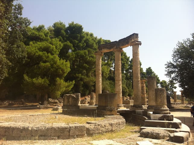
In western Peloponnese, in the beautiful valley of the Alpheios river, lies the most celebrated sanctuary of ancient Greece. Dedicated to Zeus, the father of the gods, it sprawls over the southwest foot of Mount Kronios, at the confluence of the Alpheios and the Kladeos rivers, in a lush, green landscape. Although secluded near the west coast of the Peloponnese, Olympia became the most important religious and athletic centre in Greece. Its fame rests upon the Olympic Games, the greatest national festival and a highly prestigious one world-wide, which was held every four years to honour Zeus. The origin of the cult and of the festival went back many centuries. Local myths concerning the famous Pelops, the first ruler of the region, and the river Alpheios, betray the close ties between the sanctuary and both the East and West.
88 Recomendado por los habitantes de la zona
Archaia Olympia
In western Peloponnese, in the beautiful valley of the Alpheios river, lies the most celebrated sanctuary of ancient Greece. Dedicated to Zeus, the father of the gods, it sprawls over the southwest foot of Mount Kronios, at the confluence of the Alpheios and the Kladeos rivers, in a lush, green landscape. Although secluded near the west coast of the Peloponnese, Olympia became the most important religious and athletic centre in Greece. Its fame rests upon the Olympic Games, the greatest national festival and a highly prestigious one world-wide, which was held every four years to honour Zeus. The origin of the cult and of the festival went back many centuries. Local myths concerning the famous Pelops, the first ruler of the region, and the river Alpheios, betray the close ties between the sanctuary and both the East and West.
Naturelover
30 wonderful waterfalls.Be warned this is only suitable for adventurous travelers. Be sure you are confident in your driving and navigation skills before you go. Some of them are within 10 minute walking distance from the road, while the rest need some trekking. Visit on a spring or early autumn day as too much heat or rain might destroy your visit. Take your swimsuit and have fun !
6 Recomendado por los habitantes de la zona
big waterfall nemouta/ Καταρράκτης Νεμουτας
30 wonderful waterfalls.Be warned this is only suitable for adventurous travelers. Be sure you are confident in your driving and navigation skills before you go. Some of them are within 10 minute walking distance from the road, while the rest need some trekking. Visit on a spring or early autumn day as too much heat or rain might destroy your visit. Take your swimsuit and have fun !
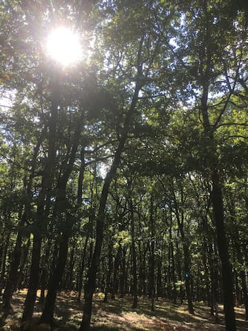
It’s the only flat forest in Greece situated on the boundaries between Elis, Arcadia and Achaia, at an altitude of 600meters. It covers a total surface of 218.000 acres and it consists mainly of broadleaf oaks.
Foloi oak forest is a designated site under NATURA 2000 that dates back to ancient times. It’s the only flat forest in Greece situated on the boundaries between Elis, Arcadia and Achaia, at an altitude of 600meters. It covers a total surface of 218.000 acres and it consists mainly of broadleaf oaks.
The oak forest of Filoi with its ancient trees starts in a distance of 15km from the village Lala.
Foloi oak forest
It’s the only flat forest in Greece situated on the boundaries between Elis, Arcadia and Achaia, at an altitude of 600meters. It covers a total surface of 218.000 acres and it consists mainly of broadleaf oaks.
Foloi oak forest is a designated site under NATURA 2000 that dates back to ancient times. It’s the only flat forest in Greece situated on the boundaries between Elis, Arcadia and Achaia, at an altitude of 600meters. It covers a total surface of 218.000 acres and it consists mainly of broadleaf oaks.
The oak forest of Filoi with its ancient trees starts in a distance of 15km from the village Lala.
The Neda is a river in the western Peloponnese. It is 31 km long.There are a well known waterfalls near the village of Platania. River waterfalls with natural carved pools.. The scenery is amazing!
It is a little bit difficult to get there.There are two different ways: the Ilia way and the Mesinia way.I would suggest the Mesinia road,because it has better road,especially for the last part and it has more parking area.If you choose the Ilia way(from Figalia,couple of miles after Perivolia)you have to bear in mind that there are 3-4 miles with bad steep gravel track road with limited parking area at the end.At the end of the road,the foot path begins,it is about half a mile up and down a hill Better to wear trainers.
55 Recomendado por los habitantes de la zona
Cascadas de Neda
The Neda is a river in the western Peloponnese. It is 31 km long.There are a well known waterfalls near the village of Platania. River waterfalls with natural carved pools.. The scenery is amazing!
It is a little bit difficult to get there.There are two different ways: the Ilia way and the Mesinia way.I would suggest the Mesinia road,because it has better road,especially for the last part and it has more parking area.If you choose the Ilia way(from Figalia,couple of miles after Perivolia)you have to bear in mind that there are 3-4 miles with bad steep gravel track road with limited parking area at the end.At the end of the road,the foot path begins,it is about half a mile up and down a hill Better to wear trainers.
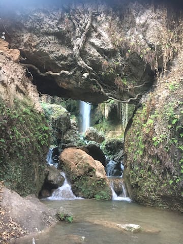
Καταρράκτης Καλαμάρης i
The Kalamaris waterfall, Gialova waterfall, is a nice 10 meter high waterfall north of Gialova
From Gialova drive north and soon take the exit right to Shinolaka. After 900 meter there is a (greek) blue traffic sign for the Kalamaris waterfall (Καταρράκτη Καλαμάρη) pointing to the right. Follow the dust road until it ends at an olive orchard (gps 36.957323, 21.727766). You can park your car here. From the parking it is a 10-15 minute walk east until you reach the Kalamaris waterfall.
When there is enough water in the Kalamaris waterfall it is gorgeous and one of the most beautiful waterfalls in Greece. In summertime the stream can be very small but still the scenery is gorgeous and very picturesque.
6 Recomendado por los habitantes de la zona
Καταράκτης Καλάμαρης - Kalamaris Waterfall
Καταρράκτης Καλαμάρης i
The Kalamaris waterfall, Gialova waterfall, is a nice 10 meter high waterfall north of Gialova
From Gialova drive north and soon take the exit right to Shinolaka. After 900 meter there is a (greek) blue traffic sign for the Kalamaris waterfall (Καταρράκτη Καλαμάρη) pointing to the right. Follow the dust road until it ends at an olive orchard (gps 36.957323, 21.727766). You can park your car here. From the parking it is a 10-15 minute walk east until you reach the Kalamaris waterfall.
When there is enough water in the Kalamaris waterfall it is gorgeous and one of the most beautiful waterfalls in Greece. In summertime the stream can be very small but still the scenery is gorgeous and very picturesque.
Caiafas Lake belongs at the municipality of Zacharo.The lake is separated from the sea forming a remarkable wetland extended in 490 acres, which was covered with tall pine trees until the fire in 2007 composing the forest of Strofilia. The lake remains an important wetland hosting fish, eels, turtles and several emigrating species. With approximately three kilometers in length and 600m in width and the small Agia Ekaterini Islet connected with a small strip of ground to the rest of the land, is a unique synthesis of a natural landscape. It also hosts a nautical-sport center of water sports such as rowing and water skiing. There are the thermal springs "Kaiafas Thermal Spa" and you can try curative baths.
31 Recomendado por los habitantes de la zona
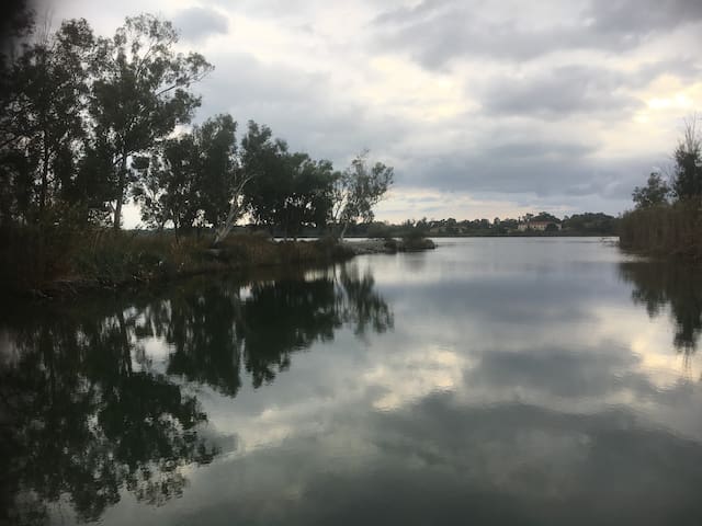
Kaiafas Lake
Caiafas Lake belongs at the municipality of Zacharo.The lake is separated from the sea forming a remarkable wetland extended in 490 acres, which was covered with tall pine trees until the fire in 2007 composing the forest of Strofilia. The lake remains an important wetland hosting fish, eels, turtles and several emigrating species. With approximately three kilometers in length and 600m in width and the small Agia Ekaterini Islet connected with a small strip of ground to the rest of the land, is a unique synthesis of a natural landscape. It also hosts a nautical-sport center of water sports such as rowing and water skiing. There are the thermal springs "Kaiafas Thermal Spa" and you can try curative baths.